 |
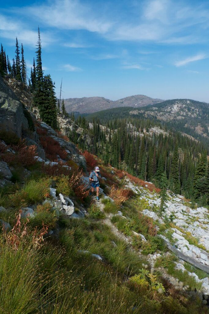
| Jamie and Amelia in the Bob Marshall (photo credit self timer) |
Intrigue and inspiration drew me to cartographer Amelia Hagen-Dillon, whom I became aware of through her MTC blog entry. What I admired about her was that she succeeded at what many trail runners aspire to; she turned her passion for the outdoors into a living. I wanted to learn more about Amelia, and especially about what sparked her desire and courage to start a new life mapping Montana's trails. I ordered one of her waterproof maps at cairncarto.com for $12.95 and it arrived in my mail just two days later. My new map's exceptional quality was immediately obvious. It felt smooth and durable, and its color scheme and navigational lines were highly detailed yet easily distinguishable. I am excited for Spring so I can start exploring my new map's trails. I hope my chat with Amelia and her beautiful map work will somehow inspire you too to explore wild places, and more importantly, to follow your passions wherever they lead you.
Please tell the readers a bit about yourself and your journey into cartography.Quick Bio: I grew up on a sheep farm in Vermont in a pretty rural area so I spent a lot of time playing and exploring in the woods behind my house. I was a total bookworm as a kid and I think my love of maps grew out of my love of books and a desire to understand how all the places I was reading about fit together.
I went to college in Maine where I studied Environmental Science and spent as much time as I could exploring the mountains in Maine and Northern New Hampshire. I took a few GIS (mapping software used for all different kinds of spatial analysis) classes and loved them.
My last two summers in college I worked for a non-profit based in Bozeman doing the fieldwork for several landscape-level research projects which is where I learned how to use a lot of the GPS and software that I use now to make maps. I also fell in love with the state of Montana and Jamie, who is my partner in life and business now :)
I moved to Missoula immediately after I graduated from college and Jamie and I started scheming about making maps of some of our favorite places. In 2010 we spent the whole summer GPSing trails in the Bob Marshall and we printed our first map (with help from a kickstarter campaign) a year later. We have printed at least one map a year since then.
 |
| Amelia on the high ridges of the Selway Bitterroot (Photo credit Jamie Robertson) |
What is unique about your maps that a trail runner would find useful?
I think the most useful things for runners on our maps are the really clear topography and the mileage between trail junctions. The combination of (well-labeled) contour lines and shaded relief make it much easier to see what the terrain is like than contour lines alone. The mileage between junctions is really helpful for planning routes especially if you are trying to put together a loop in an area you aren’t familiar with. What is involved in making a map?
We start by spending a few months getting to know the area. That means a lot of studying existing maps and Google Earth and talking to people who have spent time hiking or working there. Starting in the beginning of June (or whenever the snow is melted enough to follow trails) we are in the field four or five days a week hiking, running, backpacking and sometimes just driving to get to know an area. We GPS trails and we take notes on road conditions, trailhead amenities, campgrounds, and any other information we think might be useful later on. In the winter we switch to office mode and track down all the data we can find for the area. This means roads, trails, land ownership, geographic names, hydrography (rivers, streams, and lakes) and more. Since we work with data from so many different sources a big part of the process is getting it to all look good and work together. I really love the seasonal and cyclical rhythm of the whole process 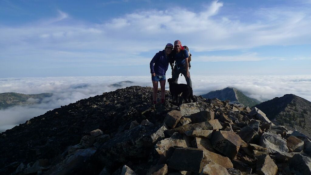 |
| Jamie and Amelia plus their dog Piper in the Pintlers (photo credit self timer) |
Describe a typical day of being out in the field making maps?
2015 was really different than previous years because Jamie started working as a cartographer for Adventure Cycling last June. Instead of spending the summer backpacking and hiking together I did most of the fieldwork on my own. I’m still figuring out what the best system for me is while I’m alone but my routine this summer was to camp in the back of the truck at or near the trailhead the night before I’m planning on GPSing a trail. I get up at first light and make coffee, eat breakfast, and feed the dog while looking over the maps for the day. I spend most of the day moving somewhere between a hike and a run so I wear running shoes and clothes and I carry my stuff in a running pack. GPSing a trail isn’t much more complicated than covering the distance on foot but I do stop to make notes about trail conditions and take points at junctions and stream crossings and anything else I think might be helpful later on. I usually cover between 15 and 30 miles and try to make it back to the truck by mid afternoon. Back at the truck I look for a creek or a lake to soak my feet in and rinse the sweat off while I eat a snack and look at the map some more. I find a spot to camp close to the next day’s objective, make some dinner and crawl into the truck. I spend a few minutes writing down what I did that day and anything important about the trail and then I read for a few hours before bed. Most of my trips last summer were just two or three days followed by a few days in town to catch up on stuff at home.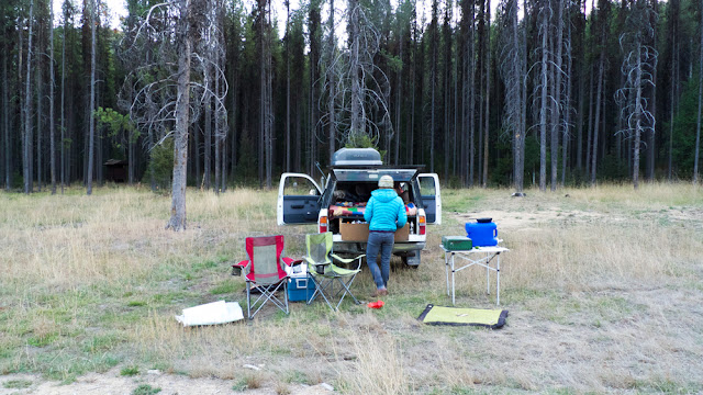 |
| Truck Camp (photo credit Jamie Robertson) |
How did you turn your love for the outdoors into a business and what is your advice for others seeking to turn their passion into a sustainable living?
That’s a tough question! We are still trying to figure that out in a lot of ways. I will say that even something you love a lot starts to feel like work if isn’t balanced out by other fun things in life or if it is creating too much financial stress. Our approach has been really conservative- we have always worked part time side jobs (or now Jamie’s full time job) to avoid going into debt as we grow our business. I think some people can handle the stress of going all in and taking bigger financial risks but for us it has worked better to take a slower and less risky route.What are a few unknown trails you discovered through map making where runners would find stunning beauty on runnable terrain?
So many places! We are so lucky here in Missoula, there are so many awesome places nearby. Some of my favorites, in no particular order:
The North Fork of the Blackfoot, especially in the fall when the larches are turning
Birch Creek (North and South forks) near Swift Dam on the east side of the Bob Marshall
Boulder Lake and the whole part of the Rattlesnake that can be accessed from Gold Creek
Watchtower Creek off the West Fork Road in the Southern Bitterroot
Wind Lakes and Graves Peak Lookout off of Highway 12 in the northern Selway Bitterroot
I could go on and on...
 |
| Map Sample, south Selway Bitterroot |
Do you have any nuggets of wisdom for others that see you as inspiration to follow their inner direction or dreams?
Oh gosh. I don’t feel qualified for that! I really don’t think that I have anything to offer except to tell people to commit to hard work and focus mixed with a little fun and not taking yourself too seriously.What is your vision for Cairn Cartographic?
We’ve been talking a lot about that as we plan 2016. I hope that in a few years we can establish ourselves as a source for the best maps available for Western Montana. Which is to say my vision is mostly more of the same: I want to keep exploring and making maps in this corner of the world. Eventually I would like to expand beyond Montana, maybe even abroad. We also have a lot of ideas for more poster-style maps like the one we made of the Bob Marshall last year. Thank you Amelia for the interesting interview! Your beautiful maps are inspiring outdoor enthusiasts to explore and respect wild and remote places. We appreciate all that you do to create such excellent maps!
Nicole Hunt
For more information visit:
http://cairncarto.com/ |
| Map sample South Bob Marshall |